Casestudy 01Philippines
Use of GPS and participatory
3D models to reclaim land on Mindanao
- description
- further information
 © G Rambaldi / ARCBC 2002
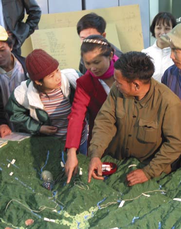
On the island of Mindanao in the Philippines, Talaandig people are part of a new movement of indigenous community surveyors. Equipped with global positioning system (GPS) receivers, these surveyors have an ambitious goal – to delineate and reclaim their ancestral territories. Their GPS records are used to create accurate three-dimensional maps through an innovative process known as participatory 3D modelling (P3DM). Coordinated by the Philippine Association for Intercultural Development (PAFID) and sponsored by the European Union, P3DM initiatives are facilitating cooperation and effective decision making among indigenous communities and government planners in two important fields: land conflict resolution and natural resource planning.
In just over five years, PAFID and its community partners have mapped over a million hectares of ancestral domains. Due to their technical accuracy and detail, P3DM maps are now accepted by the government as proof of claims for legal recognition of ancestral land rights. Previously, the bulk of indigenous lands had not been properly surveyed and had been classified as state owned. Planning officials had designated large areas for mining, logging and military installations, which led to evictions, violent confrontations and the mass dispossession of many local communities.
The P3DM models are also proving invaluable in natural resource planning. Increasing pressure on diminishing resources, such as freshwater, forests and fish, make sustainable development plans crucial to the survival of small tribes. Because the physical three-dimensional features of a P3DM model are immediately recognizable, all members – including elders and those who cannot read – are able to participate in resource planning. Such models have been used in resolving inter-tribal conflicts over resources, most notably water, and in pointing out problem areas and solutions to government planners.
PAFID's experiences demonstrate that an intelligent combination of participatory decision making and modern technology can provide solutions to land conflicts and assist in natural resource planning. The secret of the success of the P3DM approach lies in its ability to engage both indigenous community members and the authorities in an ongoing political dialogue that is mutually beneficial
Go back to case studies listing
Postbus 380
6700 AJ Wageningen
The Netherlands